


News

AIST's Next-generation Geological Map: 3D Underground View of Central Tokyo Available Online Updated in July 2021
The National Institute of Advanced Industrial Science and Technology (AIST) has completed a next-generation geological map that shows the underground structure of Tokyo’s 23 wards in three dimensions, and has made it available online. Accurate representation of the subsurface has been difficult with conventional flat geological mapping, but a 3D underground visualization was achieved by analyzing geological data from 50,000 locations through AIST’s unique 3D modeling technology. It is expected to be used for creating hazard maps and for improving infrastructure. In the future, the map will be expanded to some of the neighboring prefectures. Map production in other areas is also under consideration.
Geological and ground information is indispensable for construction and civil engineering work. In addition, the 2011 Great East Japan Earthquake caused a lot of damage to buildings and liquefaction in the Tokyo metropolitan area. This led stakeholders to understand the importance of recognizing specific characteristics of the land area. However, it is difficult to observe exposed strata in highly urbanized areas. Moreover, conventional geological maps are drawn by color-coding the distribution of strata on a 2D plane, and it is especially difficult to depict strata on plains. According to an AIST spokesperson, it is as difficult as "showing a skyscraper on a top-down 2D map" (AIST).
Therefore, the research group at AIST decided to visualize the distribution of strata in three dimensions. They first released a three-dimensional geological map of northern Chiba prefecture in 2018. Based on this know-how, the team proceeded with the production of the 3D map for the 23 wards in Tokyo, which required more extensive research and analysis.
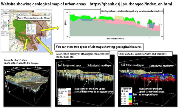
Based on AIST’s detailed underground boring survey data from 20 locations, AIST combined and analyzed data of 50,000 locations collected by the Tokyo Bureau of Construction, Civil Engineering Support and Training Center. The shape of the stratum was determined by a unique computer modeling technique, and the team succeeded in three-dimensional visualization up to several tens of meters underground for the 23 wards of Tokyo, where the geological structure is complex.
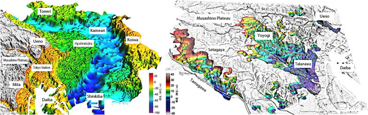
Consequently, detailed underground structures of Tokyo were revealed. The group discovered an area characterized by a spreading soft mud layer.
For the past 700,000 years, the earth has been experiencing repeated glacial periods and relatively warm interglacial periods every 100,000 years. At the peak of the most recent glacial period (115,000-11,700 years ago), sea level was 120 to 130 meters lower than today. Deep valleys were formed by the erosion of rivers on what used to be land. After that, the sea level rose. Soft “alluvial layers" made of mud fills these valleys, and this is what we see today.
In the completed geological map, one can clearly see the "buried valley" in the lowlands of downtown Tokyo. Although this fact was previously known, it was additionally found that the valley’s length in Tokyo's 23 wards alone is about 25 km. And in the bay area where the valley’s depth is prominent, it is about 80 meters deep and 3-4 km wide.
The team newly discovered that a part of the Musashino Plateau (western Tokyo), where the ground was thought to be hard, also harbored a buried valley under a soft mud layer similar to the alluvium mentioned above. It is said that a valley was formed during the glacial period 140,000 years ago, and was buried in the interglacial period between 130,000 and 120,000 years ago. There are two such spots: One stretches about 10 km and 3-4 km wide between Yoyogi and Takanawa, and the other in Setagaya ward is 10 km long and 1.5-3 km wide.
Both maps provided by the National Institute of Advanced Industrial Science and Technology
AIST released the map as “The Urban Geological Map of Central Tokyo (Wards Area)” online on May 21, 2021. Some parts of the map can be viewed through browsers on personal computers, but a corresponding plug-in is required to display the 3D images. In addition to 3D and plane views, a cross-sectional view between any two points can also be displayed.
In the future, similar work will be carried out in the southeastern part of Saitama prefecture, the central part of Chiba prefecture, and the eastern part of Kanagawa prefecture to develop a geological map covering the main parts of the Tokyo metropolitan area. The AIST team will consider production in Kansai and Chukyo areas (western Japan). Nakazawa Tsutomu (Group Leader of Geoinformatics Research Group, Research Institute of Geology and Geoinformation, Geological Survey of Japan, at AIST) said, "There are examples of 3D geological maps overseas, but I have never heard of anything this detailed. By utilizing this map, people can question preconceived notions about planes and plateaus being solid and safe. Most people would think, for example, 'This is a plateau, so there is solid ground underneath.' By getting rid of such preconceptions, it will be easier to make architectural plans.”