


News
Runner-up in World Competition to Make Deepsea Ocean Floor Map - Japan's Team Kuroshio Updated in August 2019
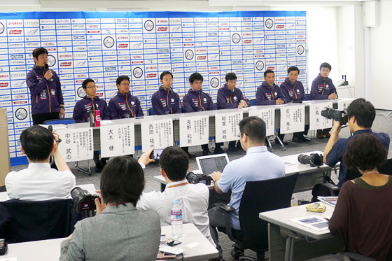
To quickly create a topography map of the deep-sea in a wide specified area using unmanned instruments─That was the objective of the Shell Ocean Discovery X Prize. Teams of scientists competed with their measurement technologies in deep-sea, where modern technology is hard to reach. Japan's Team Kuroshio consisting mainly of Japan Agency for Marine-Earth Science and Technology (JAMSTEC) won the Runner-Up Prize next to an international team based in the United States. A total of 32 teams registered to participate from around the world. Kuroshio's accomplishments were reported in Tokyo on June 5.
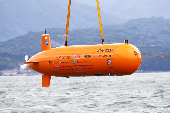
The sea accounts for 70% of our earth. Out of that 70%, only 1% has been explored enough to have a detailed topographical seabed map. The average depth of the sea is 3,700 meters and deepest parts of the ocean bed is about 11,000 meters. It is impossible to pull down a power cord from the ship to explore the deepest parts of the ocean. Moreover, radio waves cannot travel through seawater. Sonic waves are used to send signals, but it is incomparable to remote control using radio waves. Therefore, an automated unmanned vessel loaded with measuring instruments would travel deep underwater to crate ocean floor maps.
Shell Ocean Discovery X Prize is the world competition to see who can make the most detailed ocean floor map. There are some basic rules. The supporting mother ship should not enter the sea areas specified in the competition. In other words, the areas to be explored must be completely out of human reach. The seabed map will be submitted within 48 hours after completion of survey. In the past, deep-sea topography surveys had been conducted in a relatively narrow area, but in this competition, a large area measuring 500 square kilometers (almost the size of Guam*) was designated to each team and participants aimed to make a topographical map in a limited time-frame. It is almost like making the ocean floor map for the northern half of Tokyo Bay without human interference.
Kuroshio consisted of 30 members from 8 organizations ranging from Japanese research institutes, universities and private companies. Out of 9 teams which won the first round of the competition, some teams withdrew from the competition due to inevitable circumstances. The remaining 5 teams went to compete in the final round which took place during November-December 2018. The destination for the final round was only revealed in July 2018─an elongated narrow sea area off the coast of Kalamata, south of Greece, where the depth ranged from 700 to 4000 meters. Contestants were to survey the 4000-meter deep waters within 24 hours and cover topography for an area more than 250 square kilometers. They also had to take photographs of the seabed.
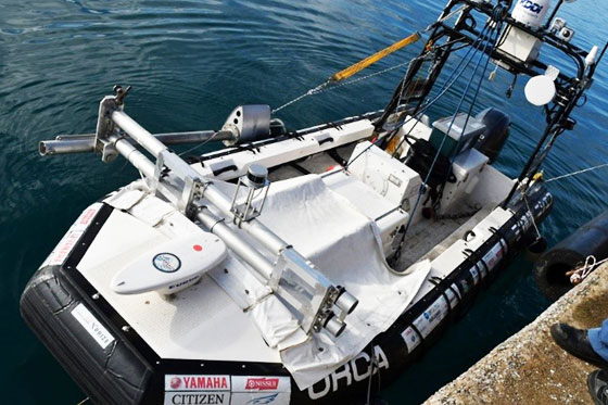
Team Kuroshio was supposed to use two unmanned submerging vessels but one went out of order. The remaining vessel also faced trouble while disconnecting itself from the unmanned towing ship. Still, it managed to travel up and down the designated area during stormy weather and surveyed the deep seabed for about 13 kilometers within 23 hours and 4 minutes. The maximum diving depth was 1.021 meters, and the scope of the survey was 33.5 kilometers wide from south to north, and 5 kilometers wide from east and west. This end result however, was not enough to clear the competition's initial objective.
The grand prize went to the international team GEBCO-NF based in the United States. Although detailed comments from the judges are still unknown, Takeshi Nakatani, JAMSTEC researcher and one of the team leaders for Kuroshio stated the reason for becoming the runner-up out of 32 teams: “It was probably due to the size of the area we surveyed and how we captured the topography in detail. Also, how we managed sonar signals was probably evaluated, too. We're simply happy to be the runner up among so many outstanding competitors.” Team Kuroshio won the runner-up prize of 1 million US Dollars.
Shell Ocean Discovery X Prize Official Website:
https://oceandiscovery.xprize.org/prizes/ocean-discovery/articles/ocean-discovery-winners-announced
Team Kuroshio Website:
http://www.jamstec.go.jp/team-kuroshio/en/