News
Real-time Prediction System to Alert Flooding in Japanese Cities by Waseda University and University of Tokyo Updated in July 2019
A joint-team of Waseda University and the University of Tokyo announced on May 20 that they developed a system to predict flooded areas in the city on a real-time basis when heavy rain hits Tokyo. It will help safe evacuation of residents and to help find ways to counter floods in the wake of recent torrential “guerilla rains.” By the end of June, the research group will begin testing the system within Tokyo’s central 23 wards, aiming for full operation by the 2020 Tokyo Olympics when many inbound visitors are expected.
The members of the research group include Masato Sekine (Professor at Waseda University Faculty of Science and Engineering), Masaru Kitsuregawa (Professor at the University of Tokyo EDITORIA-Earth Observation Data Integration& Fusion Research Institute), Eiji Ikoma (Specially Appointed Associate Professor/EDITORIA), and Akio Yamamoto (Specially Appointed Research Associate/EDITORIA).
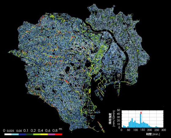
Based on the dynamics principle, the system accurately predicts flooding by calculating the flow of rainwater in the city including water inside sewage and urban rivers. In developing the system, large amounts of infrastructure data related to the flow of rainwater was fed into the computer in advance. Data from the Ministry of Land, Infrastructure, Transport and Tourism (MLIT) and Japan’s Meteorological Agency were also incorporated into the system for a more accurate prediction. This enables rain forecast for every 60 seconds in every 250-square-meter-sections of Tokyo’s 23 wards. Flow of rainwater through sewage and urban rivers were calculated for targeted sections to visually mark the depth of flood on the map.
The system was named S-uiPS (Sekine’s urban inundation Prediction System; pronounced “swips”), and can be used for other large cities outside of Tokyo.
If temperature of the atmosphere rises, there will be more extreme torrential rain as global warming progresses, because more water vapor can be contained. In urban cities, rainfall shall flow to rivers and reservoirs through sewage pipes, but when rain exceeds expected volume, it could trigger serious damage. For instance, excessive water could overflow into underground paths or shopping centers near major stations or into hollow indented sections of urban roads.