


News
A Demo Test to Avoid Unpassable Roads in Case of Tsunami – An Evacuation Experiment Took Place in Kawasaki City Updated in February 2019
How smoothly can people evacuate during major disaster with help from new technologies like smartphones and high-speed computers? On December 9, 2018, a demo test was conducted in the city of Kawasaki (Kanagawa prefecture) to help citizens evacuate from potential tsunami.
Since 2017, the city is involved in a joint project with Tohoku University International Research Institute of Disaster Science (IRIDeS), University of Tokyo Earthquake Research Institute (ERI) and Fujitsu to reduce tsunami damage through the use of ICT in the Kawasaki coastal area. The imminently feared Nankai Trough Megaquake is estimated to hit Kawasaki any time. In 1605, the Keicho Earthquake had triggered a very large-scale tsunami in Kawasaki and there is a possibility for a similar one to come back. The demonstration test was conducted as part of the joint project.
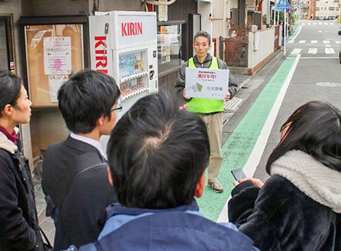
90 citizens participated in this test under the assumption that a strong earthquake had destroyed buildings and that some parts of the city were flooded by tsunami. Participants downloaded the test app on their smartphones and were asked to evacuate by looking at the map shown on the app. By assuming that certain roads were not passable from flooding, fire or debris of collapsed buildings, project staff stood on such closed roads by holding a sign that said “Unpassable!” or “Collapsed Buildings!” A participant who reached such a danger-spot would push the “Disaster Notification” button on the smartphone screen. Based on the location of that participant, information about that specific road blockage would be notified to other participants’ smartphones.
On the smartphone screen, participants would choose and feed back the reason on why the road is blocked.
Participants split into small groups to reach the evacuation point Shincho Elementary School (Address: Watarida-Shincho, Kawasaki-ku, Kawasaki-shi) from different starting points. As they progressed by looking at the app, red X marks would start to appear on the map to show blocked roads. Participants would have to evacuate to the elementary school through unblocked passable routes.
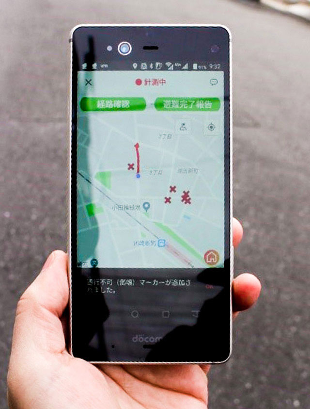
For some participants, their maps were surrounded with many X marks that they had to make a big detour to reach the elementary school. In some instances, X-marked danger spots had become passable in a short while. After the demo, participants voiced their thoughts:
“Can tech-unsavvy senior citizens make use of this app?”
“An audio guide should be incorporated in the app.”
“The app needs a function to correct information.”
The joint-project will reconsider how much this system helped evacuation actions and what needs to be improved. This time the test took place within an elementary school district to collect basic data for future practical application.
Technically, the joint project is considering to cover evacuation routes of one whole city, or to instantly calculate potential danger spots where evacuees may concentrate. This can be done by using high-speed computers. Instead of having each person figure out evacuation routes based on X marks, the project is now considering to suggest the shortest evacuation route for each citizen through smartphones, just like a car navigation system would.
Recently, communication technology has become more sophisticated, so that a large amount of data can be processed quickly. The number of technologies that can be used for disaster prevention has increased. However, even with cutting-edge technology, it will not help unless it leads to successful evacuation and is widely accepted by society. In the end, we humans are the ones who have to evacuate. Kawasaki is not the only city at risk from natural disasters. This demo test was a meaningful in attempting to explore the use of modern technology to find evacuation routes within a tsunami-flooded city.