


News
Reproducing Destructive Winds with Drones and Computers Updated in February 2018
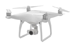
Handy tools spread quickly. Flying drones have become commonplace now. It is not unusual to see aerial photos taken by drones on various media
Scientists conduct research under a limited budget. If you can achieve your purpose easily with less money, there is no waiting in using such economical means. One example is the measurement of terrains. It is common to measure terrains with a laser shot from a small aircraft, but you can save much cost by using a drone instead. And if you could develop a new technology in an economical manner, you may be able to contribute it back to society.
Through computer simulation, Associate Professor Takanori Uchida and his group (Kyushu University Institute of Applied Mechanics and other researchers) made use of aerial photographs to successfully reproduce turbulent winds that damaged a windmill. Although this calculation required detailed highs and lows of terrain data, it only took 1/10 of cost needed to fly an aircraft.
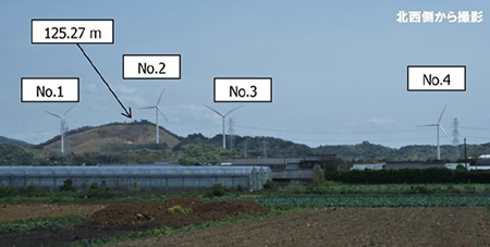
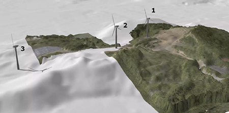
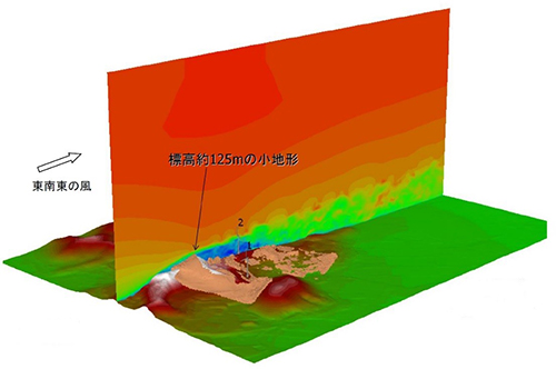
The simulation was conducted for a windmill owned by a private company located in the city of Tahara-shi, Aichi Prefecture. When the wind blew from east-southeast, many windmills broke down. Something seemed to be happening in the wind, but the wind is invisible to the human eye. To explore the specific image, it was effective to simulate wind movements by computer and to reproduce the wind flow.
To calculate and simulate real wind, you need data that demonstrate terrain and land conditions. Thus, the drone was introduced. On this drone, the team loaded cameras that can shoot in normal visible light. While photographing at an altitude of 75 meters vertically and horizontally through an automated program, the cameras continuously shot pictures of targeted points. By combining about 570 such photos with altitude data obtained from Japan Geospatial Information Authority (GSI), the team reproduced detailed topography around the windmill. According to Uchida, it would be even better if the topographic data reach a more precise resolution at tens of centimeters (e.g. 40 cm-60cm) in order to reproduce winds that adversely affect smaller windmills. The object of this research was a large windmill, but by combining GSI data of 5-meter resolution and the data from the drone, the final resolution used in the research improved to 1 meter.
Based on data showing the topography and the influence of trees, the team simulated the turbulent wind flow. As a result, when the wind blew from east-southeast, it hit a small mountain with an altitude of 125 meters and the wind was disturbed irregularly to cause turbulence. This turbulence shook the windmill's neck, and indicated the probable cause of the breakdown. Based on these results, Uchida and other researchers on the team would further like to investigate when to stop windmill operation under what type of wind-flow, in order to prevent future damages.
Photos courtesy of Japan Science and Technology Agency
Photos courtesy of Japan Science and Technology Agency
Photos courtesy of Japan Science and Technology Agency
Photos courtesy of Japan Science and Technology Agency