


News
Silent Earthquakes Discovered in the Shallower Parts Beneath Oceanic Floor - Probable Cause of Tsunami Occur from Tidal Fluctuations Updated in January 2018
Massive earthquakes can occur frequently in boundaries where ocean floors or oceanic rock plates from the Pacific Ocean and the Philippine Sea submerge westwards under the continental plate where Japan sits on. The March 11, Great East Japan Earthquake of 2011 was caused by clash of these plates. When the oceanic plate submerges underneath, it deforms the ground and gradually accumulates strain. When these strains can no longer stand, it suddenly turn into a big earthquake. Once the earthquake goes by, the strain is released, and the slippage becomes minimal.
Sometimes such slippage among rock plates can occur at a much slower pace. They are named slow slip movements or silent earthquakes. Because they move slowly, they do not bring violent shakes but helps to release strain. And wherever a slow slip is observed, there may be rock plates that are accumulating huge earthquakes. The slow slip movements can influence these plates. Therefore, we can say that slow slips are closely related to to big earthquakes.
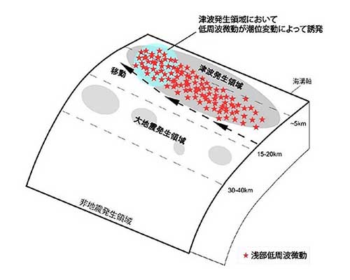
Satoshi Katakami (Kyoto University RCEP-Research Center for Earthquake Prediction; doctoral program) and his group recently announced that slow slips are related to the vertical up-down movements from tidal ebbing and flowing. In plate boundaries, earthquakes can occur in both deeper sections of the submerged zones (subduction zones) and in shallower sections. Slow slips in the deeper sections were pointed out to have some kind of relationship with tidal fluctuations, but for the shallower parts, it is the first time that such associations were established. If a rock plate should slip in the shallower section, it can trigger a great tsunami. This research is significant because it tries to understand how strains in the rock plate are released in submerged ocean floors, which in the end could cause big tsunamis.
The research team analyzed the slow slip movements of 2013 June, off the Pacific Ocean in southern Kyushu. Here, the Philippine Sea plate submerges from south-east, under the Eurasian plate where Japan sits on. The rock plates near this plate boundary slipped slowly. From ocean-bottom seismometers, the team found that the rock plate shifted slowly from the southern tip towards north over a period of one month. The east-west movements were measure to be 70 kilometers while south-north movements were measured to be 150 kilometers.
The correlation with oceanic tide was discovered from low-frequency tremors which occurred simultaneously with this slow-slip. The slippage which started from the south had moved north and at the northern tip where the slip was about to stop, tremors occurred due to the fluctuation of sea level. Some tremors occurred when the sea level was low and some occurred when the sea level was high.
As to the reason why such tremors in the shallower sections are related to the change in sea level, Katayama explains that “once the rock plate starts to shift, slippage tends to escalate even more and it starts to react to even the slightest stimulation like the ebbing and flowing of the ocean.”
In the Pacific Ocean offshore of Japan, there are large grooves or hollows like the Japan Trench, Nankai Trough and the Ryukyu Trench, located at boundaries where the oceanic plate submerges into the continental plate. Research to clarify properties of these trenches which can cause gigantic earthquakes are extremely important in warning society of the imminent danger of upcoming earthquakes or big tsunamis.
Photos courtesy of Japan Science and Technology Agency