News
Typhoon's Strong Winds to Protrude Outward from Global Warming Updated in October 2017
Yearly disastrous typhoons are becoming really problematic. Even in research trying to reveal their mechanisms on computer.
First of all, the pressure at the typhoon's center is very low. The central pressure of Typhoon Number 18 or Typhoon Songda which crossed over Japan during September 13-18, fell to about 930 hectopascal. Atmospheric pressure on the ground is usually around 1000 hectopascal. Low central pressure means that the air pressure can suddenly change in a narrow area. Therefore, in order to calculate the structure of a typhoon by computer, it is necessary to precisely reproduce these narrow areas. Otherwise, one cannot catch up with rapid changes. However, this will result in enormously complex computations to the extent that it may burden the research itself.
Typhoon's energy source is vapor emitted towards the atmosphere from warm sea level waters. When vapor rises and cools, it turns into water and ice. Heat is emitted in this process. This heat warms the atmosphere even more and warmed air can shoot up violently. Although a typhoon's diameter is usually about several hundred kilometers, its altitude is about 15 kilometers. In short, it is as thin as a rice cracker. If researchers cannot compute the small ascending current occurring in this thin layer stuck to the earth's surface, they would not be able to capture the typhoon's fundamental characteristic. Researchers would have to use special equations that take up time to calculate.
The team of postdoctoral researchers headed by Yohei Yamada at JAMSTEC (Japan Agency for Marine-Earth Science) targeted this tricky typhoon and calculated typhoon movements for the entire earth for a period of 60 years. Unless they could use an extremely high-performance computer, they would not have been able to come up with results. The team had used one of world's fastest supercomputers: RIKEN's K computer. * The team programmed “K” to calculate how typhoon structures may change as global warming progresses.
As global warming escalates, total number of typhoons decrease and stronger typhoons are estimated to increase. This fact is also described in IPCC's 5th assessment report of 2014 (Intergovernmental Panel on Climate Change). As global warming suppresses ascending air currents in tropical areas, tropical cyclones which eventually become typhoons are less likely to occur. But because the amount of vapor energizing the typhoon would increase, each typhoon can become powerful, once it is born. These are already known facts.
However, there had never been such high-resolution calculations to clarify structural changes of typhoons between present and future. The JAMSTEC team was able to challenge this huge task
On a computer, Yamada's team reproduced the climate during 2075-2104, a future era where global warming would advance. Then, they compared the results with data from 1979-2008. From the above two eras, they compared “tropical cyclones developed to the level of becoming a typhoon” (hereinafter typhoon). As a result, the average number of typhoon occurrences decreased by 22.7% for the entire earth, while strong typhoons with central pressure below 945 hectopascals increased by 6.6%. The amount of rain falling within 100 kilometers from the center also increased by 11.8%.
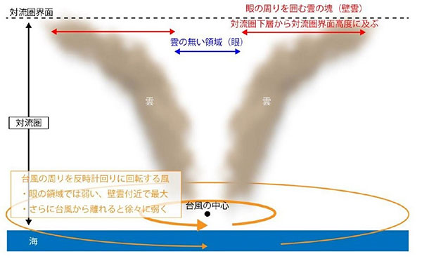
Moreover, they compared the characteristics of strong typhoons with central pressure of 920-945 hectopascal between present and the future. At 50 kilometers form the center of the typhoon, the counterclockwise wind was strongest for both present and future. However, in the future where global warming would be more prominent, wind speed would not weaken outside the typhoon. Even if central pressure is the same, future typhoons will bring on more damage far beyond the typhoon's center.
This is due to the increased amount of released heat that come from rising steam. Consequently, the rising air current becomes stronger, building a high wall of clouds around the eye of the typhoon. As a result, the typhoon would protrude outside its estimated proportion way up in the sky. Strong winds will blow under the wall of clouds and thus, lead to the protruded strong winds outside the typhoon.
In this study, the horizontal resolution of the four points on the compass (north, south, east and west) was 14 kilometers. In the typhoon, many cumulus clouds like thunder clouds can form in hot summer evenings. These clouds are important as mechanisms shaping a typhoon, but its size is only a few kilometers at most. Therefore, individual clouds were not properly calculated in this research. According to Yamada, "if we try to calculate each cloud, the amount of computation will increase further, to require a computer with even higher speed." In the atmosphere, large scale phenomena and small phenomena influence each other in a complex manner. In order to clarify the origin of large typhoons, it is necessary to capture smaller phenomena precisely, to reproduce them and to calculate them.